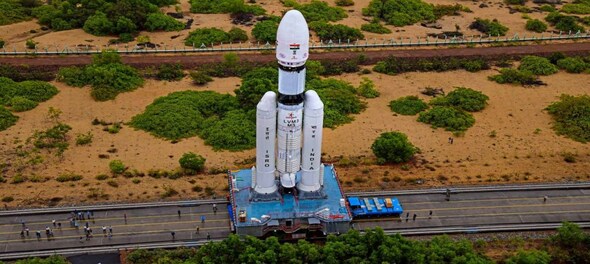
The Indian Space Research Organisation (ISRO) is likely to launch a new navigation satellite, the NVS-01, aboard the Geosynchronous Launch Vehicle or GSLV Mk-II, on May 29, according to reports. The last navigation satellite from ISRO was launched in 2018, and the new one will be launched from Sriharikota to replace an old satellite. The aim of the launch is to maintain the functioning of a navigational system named NavIC, comprising seven satellites.
“The launch of NVS-01 is scheduled for around May 29. This will be a return flight mission for the GSLV launch vehicle, which will carry the next-generation NavIC satellite. This satellite will replace the IRNSS-1G satellite launched in 2016,” a senior ISRO official told the Hindustan Times.
ALSO READ |
IRNSS-1G was among the several satellites launched by the ISRO as a part of a constellation of navigation satellites.
The Navigation with Indian Constellation (NavIC) satellite system by ISRO was launched to meet the “positioning, navigation and timing” requirements of the country and to reduce dependence on foreign systems.
The system was previously known as Indian Regional Navigation Satellite System (IRNSS).
The NavIC has a constellation of seven satellites and a network of ground stations operating 24x7.
Three of the total satellites are placed in the geostationary orbit while the other four satellites are in the inclined geosynchronous orbit.
The control centre on the ground network has a precise timing facility, range and integrity monitoring stations, etc.
The NavIC system provides two types of services to the country, the first is standard position service for civilian purposes and the second is restricted services for defence and strategic purposes.
NavIC signals are capable of providing position accuracy better than 20m and timing accuracy better than 50ns.
ALSO READ | ISRO to launch 750 kg Singaporean satellite TeLEOS-02 on the PSLV rocket on April 22, check details here
The coverage area of the system goes 1,500km beyond the borders of India.
The NavIC system was launched with a specific aim to end the dependence on foreign satellite systems like the Global Positioning System (GPS) for navigation service requirements especially for “strategic sectors”.
Systems like GPS may not be reliable under specific circumstances as they are operated by the defence agencies of other countries.
In situations like those seen in the Kargil War, these navigation services or their data can be denied to India.
With NavIC the Indian government also aims to promote local industry to develop indigenous NavIC-based solutions.
(Edited by : Sudarsanan Mani)
Check out our in-depth Market Coverage, Business News & get real-time Stock Market Updates on CNBC-TV18. Also, Watch our channels CNBC-TV18, CNBC Awaaz and CNBC Bajar Live on-the-go!


Mark Mobius reveals how markets will react if NDA wins 400+ Lok Sabha seats
May 15, 2024 8:09 PM
Wine shops and bars to remain shut for 4 days in Mumbai in 4 weeks, check details
May 15, 2024 7:52 PM
INDIA bloc will win majority seats in Bihar, says Tejashwi Yadav
May 15, 2024 4:20 PM

